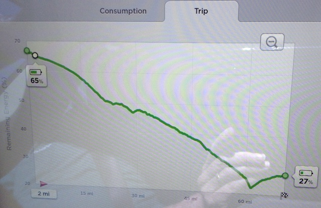
blackheart, as I mentioned, Tesla's software does what you want up to a point. I've been told (by Tesla during a presentation) that Tesla's predictive algorithm takes into account -
* Inside temperature
* Outside temperature
* Elevation
* Wind
* Speed
When pressed, the presenter was unable to answer -
1. What is meant by 'speed'? Is is speed limit or some % above or below the speed limit or is it based on Tesla data mining of their own cars over the route in question?
2. What is the perceived effect of outside temperature, recognizing that the battery pack is temperature-controlled? Perhaps simply for the climate-control system, which gets us also to the inside temperature settings?
3. Does elevation also factor in reduced air density at higher altitudes (decreased wind resistance), or are they just looking at ∆ elevation?
4. Wind: presumably they are looking at windspeed and direction along the route at some future time (or is that in the present)? This could be a biggie, even for a low-Cd vehicle like the Tesla.
5. As I'm driving, what effect does my driving have on the endpoint: does it presume that my driving style will remain constant or does it merely do a revised calculation based on the energy I've used up to this point in time?
These are just a few of the variables that should be taken into account. I need to take a snapshot of Tesla's wonderful predictive "Trip" screen that constantly updates the end SoC during the trip. Incredibly accurate if you drive "normally", and I've been able to handily beat it and raise the end-SoC the few times that I felt I needed a better margin at the end.
As far as the i-MiEV is concerned, IMO there's no point in developing such software. First off, it would have to emulate or link to PlugShare to know where all the charging stations are, which is a continuously changing variable. Even if we ignore that and manually enter locations, we know right off the bat that for any highway trip, recognizing that one always wants to have a bit in reserve, that with normal temperatures and no wind and no elevation changes -
* 40 miles is comfortable
* 50 miles is doable
* 60 miles is pushing it
* 70 miles takes some serious hypermiling
Blackheart, using your example of a 250-mile trip, you would like to automate this process? Developing such software is not something I'd be inclined to fund unless I was an auto manufacturer - heck, this was promised by Nissan for the Leaf five years ago - what have they done so far?
I suspect that with the nextgen "200-mile" BEVs we'll be seeing such software come with the car. All to give innumerates a warm fuzzy feeling...
OK, I'll crawl back down in my hole...
 Edit -
Uh, crawled back out of my hole as my wife just sent me the snapshot she took of the Tesla screen predicting the SoC at the end of a short trip. What's interesting in this particular trip is that there was a sharp climb followed by a long descent towards the end which caused the SoC to go back up. Amazing how most trips end up being within just a couple of percentage points of the initially predicted value. The "Trip" represents the route entered into the Tesla's Map screen, and this photograph was snapped just two miles after this trip started. Throughout our 10,000-mile cross-country Tesla adventure, this screen gave me a very nice warm fuzzy feeling.


