Ok, before proceeding, let's see if I have this straight -
START (MILE ZERO)
Orangewood and I-17
33.5457732,-112.1123152
Altitude 363m = 1191ft
FIRST CHARGING OPPORTUNITY (MILE 23.4)
Outlets at Anthem
4250 W. Anthem Way, Phoenix, AZ, 85086
https://api.plugshare.com/view/location/9621
Altitude 1902ft = 580m
SECOND CHARGING OPPORTUNITY (MILE 37.9)
Black Canyon Campground
19600 Saint Joseph Road, Black Canyon City, AZ 85324
Altitude 2078ft = 633m
END (MILE 56.1)
Cordes Junction Motel, RV Park and 50s Diner
19780 Hitching Post Way Mayer, AZ 86333
https://api.plugshare.com/view/location/67849
34°19.595'N, 112°6.966'W
Altitude 1147m = 3763ft
Edit Update: for completeness, I took the Google Maps route and dropped it into GPS Visualizer, with the following result:

Phximiev, you're right to be concerned, as no way you're going to make this in one shot with that altitude difference at freeway speeds.
I would plan on fully charging at Anthem, but then carefully driving the remainder to Cordes Junction (55mph?). If you insist on zooming at 75mph, plan on stopping at Black Canyon as well. Long trip.
Yet another edit: after looking at this graph, forget about 55mph for the six miles out of Black Canyon City up to about mile 43 - find a truck and just slowly follow him. It will only be for about ten minutes but you'll save gobs of energy not pushing the i-MiEV up that hill.
The good news is that coming back you can comfortably do it in one shot, providing you don't have a headwind.
START (MILE ZERO)
Orangewood and I-17
33.5457732,-112.1123152
Altitude 363m = 1191ft
FIRST CHARGING OPPORTUNITY (MILE 23.4)
Outlets at Anthem
4250 W. Anthem Way, Phoenix, AZ, 85086
https://api.plugshare.com/view/location/9621
Altitude 1902ft = 580m
SECOND CHARGING OPPORTUNITY (MILE 37.9)
Black Canyon Campground
19600 Saint Joseph Road, Black Canyon City, AZ 85324
Altitude 2078ft = 633m
END (MILE 56.1)
Cordes Junction Motel, RV Park and 50s Diner
19780 Hitching Post Way Mayer, AZ 86333
https://api.plugshare.com/view/location/67849
34°19.595'N, 112°6.966'W
Altitude 1147m = 3763ft
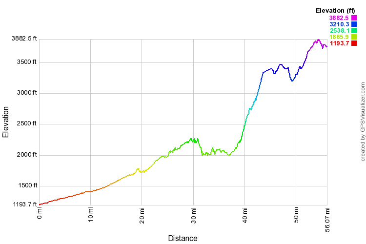
Edit Update: for completeness, I took the Google Maps route and dropped it into GPS Visualizer, with the following result:

Phximiev, you're right to be concerned, as no way you're going to make this in one shot with that altitude difference at freeway speeds.
I would plan on fully charging at Anthem, but then carefully driving the remainder to Cordes Junction (55mph?). If you insist on zooming at 75mph, plan on stopping at Black Canyon as well. Long trip.
Yet another edit: after looking at this graph, forget about 55mph for the six miles out of Black Canyon City up to about mile 43 - find a truck and just slowly follow him. It will only be for about ten minutes but you'll save gobs of energy not pushing the i-MiEV up that hill.
The good news is that coming back you can comfortably do it in one shot, providing you don't have a headwind.


